Merry Christmas !!
With the right wind conditions I'll will be in Antigua by Christmas Day, or at least that's the plan. Then I'm thinking four days of sun, sand and the sort of Sea Breezes you drink (in moderate amounts of course), before flying back to London for the mother of all New Year's knees ups. I'm flying out to Gibraltar this Thursday (30th) and then we'll slip silently out of the harbour on Saturday and wave goodbye to our last shower for 3 or 4 weeks. Our precise route is yet to be agreed but the tentative plan is to go south from Gibraltar to the Canaries and then carry on down to Cape Verde which is inside the Tropic of Cancer. This leg should take about 10 days and by the time we reach the Cape temperatures should have risen to about 26 degrees Celsius. We'll then hang a right, point the boat West and have approximately 2,150 nautical miles of Atlantic Ocean between us and Antigua.
I was looking at an Atlantic chart the other day (never let it be said I don't know how to enjoy myself), some of the depths in the middle are about 8,000 metres which is nearly as deep as Everest is high. Traditionally December is when all Tropical Storm (hurricane) activity has ceased and I'm certainly hoping that we don't encounter one, but it's been a very quiet hurricance season so far this year so it's either a low year, or they're late.
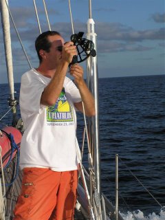
 We'll only be using the stars and the sun to navigate our way across by using a sextant, like this chap.
 The purpose of this is so that we can navigate in the event that all of our electronic navigational equipment fails or our generator (produces electricity) packs up, which is not beyond the realms of belief. We practised this a few weeks ago when we did Ocean Navigation Theory and it works. We went over to Sandown beach took some sun sights and then drove over to Ventnor and did some more. There are then numerous different calculations that have to be done on paper but eventually, and much to my surprise, it does give a position on the earth which is very accurate. This skill could be very useful in the future, everyone relies on GPS (car SatNav systems use this) but first of all it's owned by the Americans and they can either turn the accuracy down or turn it off completely and secondly it can be affected by Sun Spots. GPS has been made less accurate in the past, usually when the US is at war and when GPS was invented it was done at a time of low Sun Spot activity but this activity is due to increase in a dramatic way over the next decade so GPS could become less accurate as a result.
Enough about astro-navigation but I do find it a fascinating subject, especially when it comes to the stars and how mariners navigated before modern systems (or even an accurate time piece) had been invented, but I'll save that for smokey pub and a few beers - you lucky people.
I said I would post some pictures in my last update but I seem to be having some trouble doing that at the moment.
Here's a video of the fire fighting training that we did a few weeks ago. One of my colleagues did it. It's about 5 minutes long, there's two bits that are worth watching. Everyone knows that if you try to put out a chip fat fire with water you'll get a fireball but it's demonstrated on this video with impressive results. We all saw the amount of water that was put on the fire and it was no more than half a mug full. The second is an aerosol in a fire, it goes off with quite a bang.
I don't know if we are stopping at the Canaries or at Cape Verde but if we do I'll try to find an Internet cafe and do a quick update.
Take care, Merry Christmas and I'll see you in 07.
Paul

0 Comments:
Post a Comment
<< Home